By John Ausink

If you’ve ever gone to the Heidelberg Pastry Shoppe you’ve been in North Arlington’s High View Park area —formerly known as Hall’s Hill, an historically Black neighborhood outlined in red on the map. If you travel south on nearby N Culpepper St. and look down 17th Rd N. when you get to the bottom of the hill, you’ll notice an imposing cinderblock wall, shown behind me in the photo. What’s going on?
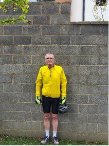
The four thick blue lines on the map show the locations of various walls, erected in the 1930s, that at one time enclosed portions of Hall’s Hill to physically separate it from White neighborhoods. If I had tried to ride down N. Culpeper St. before the mid-1960s I would have been blocked at 17th Rd N. by the wall: the only way to drive through Hall’s Hill from Lee Highway (now Langston Blvd) was via N. Edison to the west.
Some claim that Hall’s Hill was once entirely enclosed by walls of various materials, but the only segments I can document from county records and “eyewitness” accounts are the four in blue on the map. When Langston Elementary School was closed in the mid-1960s and Hall’s Hill students were assigned to a new school south of 17th Rd N., a group of Black and White citizens asked the county to open a section of the wall so students wouldn’t have to walk all the way to N. Edison and back again (14 blocks, some say) to get to school. One source says the county bought and demolished two houses and their adjacent section of segregation wall to create an opening.
If you have not visited the segregation wall, it is important to do so—and take your kids, since they don’t learn about this local injustice in school. You can easily ride your bike from Lyon Park. It’s worth noting that, while the county changed its zoning to permit the segregation walls, the walls themselves were built and paid for by White homeowners.
